Access and Trails
In this plan, access and trails refers to entry onto Crown land, by ground, water or air. Access management is a term that describes how the different types of access can be used to meet a variety of goals.
The goals of access management include:
- supporting responsible development of the area’s agricultural, mineral, range, timber, tourism and other resources;
- contributing to healthy, local communities;
- addressing the needs of fish and wildlife; and
- providing opportunities for recreational use by residents and
This plan balances competing demands for access by managing:
- development of trails
- types of use (e.g., mechanized, non-mechanized, motorized, non-motorized);
- areas of use;
- seasons of use (spring, summer, winter, all-season); and
- types of users (industrial, commercial, public, recreational).
Trails are connectors between humans and nature. The trail system of BC's goal is to link those two components together without harming one another. The goal of the BC Trails Strategy is to provide management and planning for the trail network in BC.
Throughout the province a survey was conducted including First Nations, tenure holders and other users. With information collected from this survey as well as several letters the trails system was created and completed.
The BC Trails Strategy's vision is:
A world-renowned, sustainable network of trails, with opportunities for all, which provides benefits for trails users, communities, and the province.
Due to BC's natural beauty the trail network will become world class, if managed sustainably.
Seven guiding principles ensure that the four corner stones remain as a base for the trail management. These four corner stones are First Nation involvement, tenure holders consultation, environmental stewardship and user safety.
Out of 30,000 km of trails in BC over 12,000 km are managed by Recreation Sites and Trails BC, 800 km are part of the Trans Canada Trail and 500 km are heritage trails and of First Nations.
Trails are important in many ways. They increase community quality of life, health and well-being, acknowledge First Nations and their history, raise environmental awareness and stewardship and provide a more sustainable form of transport.
Some issues connected with trails that need to be addressed are: the environmental damage they can cause if not managed properly; the safety of trail use through proper planning, more trail information such as maps, signs, brochures and maintenance; the insurance that the rules are followed and the four corner stones of safety, tenure holder consideration, environmental sustainability and First Nations involvement, aren't ignored and trail user conflicts that need to be resolved to ensure enjoyment.
Actions of the BC Trails Strategy include: to incorporate environmental actions and standards into the plan, increase environmental awareness; work collaboratively on the system to ensure safety, cultural and environmental values; to engage tenure holders, First Nations and other stakeholders; and include the transportation network system in trail planning.
In conclusion the BC Trails Strategy wants to ensure a safe trail system for everyone that doesn't damage the environment but rather raises awareness and includes First Nations and tenure holders in the decisions.
Source: Trails Strategy for British Columbia
 Recreational mountain biking attracts a large quantity of tourists and is an important activity to the residents of British Columbia. The Forest Range and Practices Act authorizes the construction and modification of trails used by mountain bikers. This way interference with First Nations and tenure holders, environmental impacts of the proposed trail, safety and location can all be assessed first. However, there are too many trails throughout British Columbia which shows that unauthorized trail construction is happening. The aim of the Ministry of Forests, Lands and Natural Resource Operations (MFLNRO) is to examine unauthorized trails as well as to authorize new trails. It is important that the new authorized trails are safe, do not damage the environment, are properly located, do not result in user conflicts, are maintained with long-term management and they are reviewed with First Nations, tenure holders and other stakeholders before approval.
The MFLNRO has four main policy objectives of the screening process for mountain bike trail authorization. These four corner stones are that the environment cannot be damaged by the construction of new trails or the use of them by mountain bikes; there are no user conflicts over the area nor the trails (public safety has to be ensured and cannot be threatened by mountain biking); First Nations, tenure holders and stake holders are to be consulted prior to trail approval; and environmental impact and safety issues need to be assessed before a new trail gets approved or an old trail is modified. MFLNRO has the right to remove any trails or facilities that go against these policy aims.
In order to achieve these goals the MFLNRO wants to collaborate with mountain bike clubs and other local organizations.
Only a registered organization or a non-profit organization can apply for a construction or modification authorization. Trail development in areas where there are no trails yet is prohibited unless a local land and resource management plan states otherwise. The party that submits a proposal must have support from the trail community and acknowledge the responsibility of long-term trail management.
If there is an unauthorized trail the MFLNRO can officially register it if the list of the following criteria is met: It has to be an appropriate location, the trail must be popular with the recreational users, it cannot have any Technical Trail Features, it can't pose a threat to public safety or create user conflict, it can't be a jeopardy to First Nations or stakeholder land use, it must not damage the environment and it has to be manageable by BC Recreation Sites and Trails.
The Mountain Bike Policy was created to address the concerns regarding mountain bike activity in British Columbia. It will ensure the four significant factors are monitored. These factors are public safety and user conflicts; First Nations, tenure holders and stakeholders consultation; and environmental integrity.
Source: Mountain Bike Trails Policy
Issues:
- Lack of access management planning, especially for undeveloped
- Lack of a public process to define appropriate access management or to resolve conflicts. Access planning processes need to include the interests of First Nations, resource developers, user groups and the
- Costs of road maintenance and access controls are not always borne by
- Access restrictions can limit opportunities for resource
- Access restrictions can have positive and negative impacts on recreation
- Access controls do not replace adequate law enforcement, for example, against
- Some access controls can only be effective if combined with other measures, such as
- Unauthorized entry past locked gates can defeat their purpose
- Important or historic trails and roads can be damaged by new road
- The public seeks better access to lakes, rivers and reservoirs, including boat-launching
- Helicopters and floatplanes can affect wildlife and wilderness values but open up more areas for
- Specific areas urgently need access management measures, for example to help conserve wildlife or reduce overuse or
- Trail development adds to road density and needs to be managed
- Trail development and modification often does not abide by regulations of application process
- There is little to no on-the-ground monitoring of new and modified trails
- Money is given to the application proponent with no accountability
- No high level management to oversee success of projects
- Many areas have high trail density, contributing to an unsustainable road density
Goals:
- A well-planned and carefully managed system of access that balances short and long-term economic, social, cultural and environmental
- Trail development planning needs to meet environmental stewardship guidelines
- Have system in place where proponent for trail development signs contract regarding trail policy regulations
- Rec Sites and Trails monitors each stage of application process with progress reports
- Rec Sites and Trails provide leadership at all stages of process
- Have Rec Sites and Trails chair meetings provide info to trail groups to fulfill stages of policy i.e. contact list for tenure holders, first nations, biologists and other users
- Rec Sites and Trails provide maps at start with enough detail to do the trail review process
- Trail density must reduce to maximum road density goal (0.6km/km2)
- Train trail group in governance and review process
- Train trail group in rec sites and trails policy and strategy and responsibilities of group before application contract is signed
- Train trail proponent and all other overlapping agencies in their roles regarding policy and regulation
- All trails identified by trail group as trail of interest must be approved by the 2016 Evergreen Stewardship Plan for the Lillooet Sub-Region
- Short list any trail proposals to 3 or 4; refer to at starting process
- Allow multi use trails only where there are no livestock, horses, cows, or range license tenures
- Prohibit trails in Mule deer, sheep, and moose winter ranges and mountain goat, sheep and grizzly bear summer ranges
- Prohibit motorized use of trails above 1500 meter elevation to prevent any risk of wildlife displacement
| Objectives | Management Direction/Strategies | Measures of Success/Targets | Intent |
| Manage access to maintain identified values described in Table 1, priority Access Management Measures | Use a variety of access controls to minimize or mitigate impacts | Priority access management measure implemented | |
| Manage trails and use described in Table 2 | Use a variety of access controls to minimize or mitigate impacts | ||
| Manage access in accordance with seasonal access maps | See Table 3 |
Access Management Approach
The approach to access management is shown on four seasonal access maps (Spring Access, Summer Access, Winter Access and All-Season Access). The approach will be phased in over the life of the plan, as resources are available. Priority access management measures are shown in Table 1. Access management terms and management intent are explained in Table 2.
The management approach applies only to multiple-use areas (that is, Crown land outside parks and ecological reserves). Park plans determine access within protected areas. The approach provides information for statutory decision makers to consider along with the economic, technical and site-specific conditions of each proposal for development. As with the rest of the plan, access management will be implemented by regulatory agencies, resource developers, tenure holders and area users, as appropriate.
The access management approach focuses on ground-based access (roads, trails) since this is the most common means and because air and water navigation is primarily a federal responsibility. In certain cases, air and water access can be managed through conditions on tenures or business permits.
Climate and topography create many natural barriers to access. Snow pack and rock slides can create undisturbed habitat that benefits wildlife. The plan takes advantage of these natural barriers to regulate motor vehicle access without costly control measures such as gates.
Multiple-use areas are open to industrial and commercial users to carry on their businesses. In developing or using these areas, and roads within them, businesses may need to address other resources, values and uses (e.g., by restricting non-business use or modifying their own use).
All multiple-use areas are open to all users for non-motorized and non-mechanized access.
Table 1: Priority Access Management Measures
| Location | Access Management Measure | Comments |
| Texas Creek road downstream of junction with Molybdenite road | Close roads to public motor vehicle use in spring (May 1 to June 30) |
Purpose is to minimize impacts to grizzly bear habitat. Existing tenure holders are allowed continued access to maintain their infrastructure and/or improvements. New tenure holders should minimize use in spring. |
| Texas Creek watershed | Close watershed to off-road, public motor vehicle use in spring (May 1 to June 30) | Purpose is to minimize impacts to grizzly bear habitat. |
| Van Horlick Creek road, at bridge at 8 kilometres | Close road to public motor vehicle use in spring (May 1 to June 30) |
Purpose is to minimize impacts to grizzly bear habitat. Temporary access control preferred (e.g., gate, lock block, abutments, etc.). Consider bridge removal if temporary control fails. |
| Davey Jones Creek road | Close road to public motor vehicle use in spring (May 1 to June 30) |
Purpose is to support regulated access management area at Red Mountain. Temporary access control preferred (e.g., gate, lock block, abutments, etc.). Consider bridge removal if temporary control fails. |
| Red Mountain road | Close road to public motor vehicle use in spring (May 1 to June 30) |
Purpose is to support regulated access management area at Red Mountain. Temporary access control preferred (e.g., gate, lock block, abutments, etc.). Consider bridge removal if temporary control fails. |
5 Mile Ridge in MU 3-32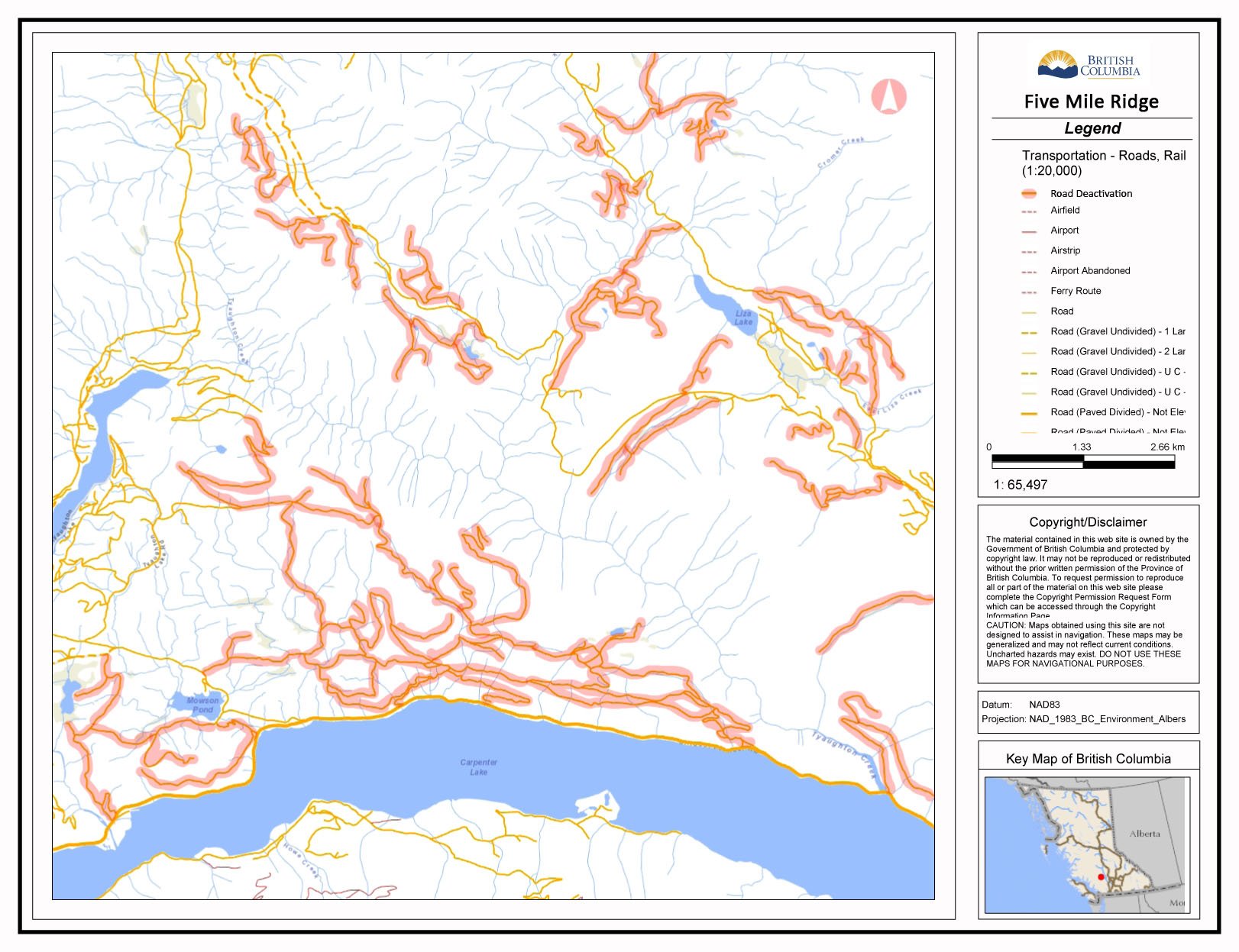 |
Deactivate all dormant logging roads; create road density reduction |
Purpose is to restrict all vehicles in: · prime mule deer winter range and spring fawning range · Grizzly bear spring habitat · Moose winter range |
Marshall Ridge in MU 3-32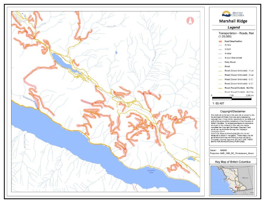 |
Deactivate all dormant logging roads; create road density reduction |
Purpose is to restrict all vehicles in: · prime mule deer winter range and spring fawning range · grizzly bear spring habitat · big horn sheep winter and spring range |
Gold Bridge in MU 3-33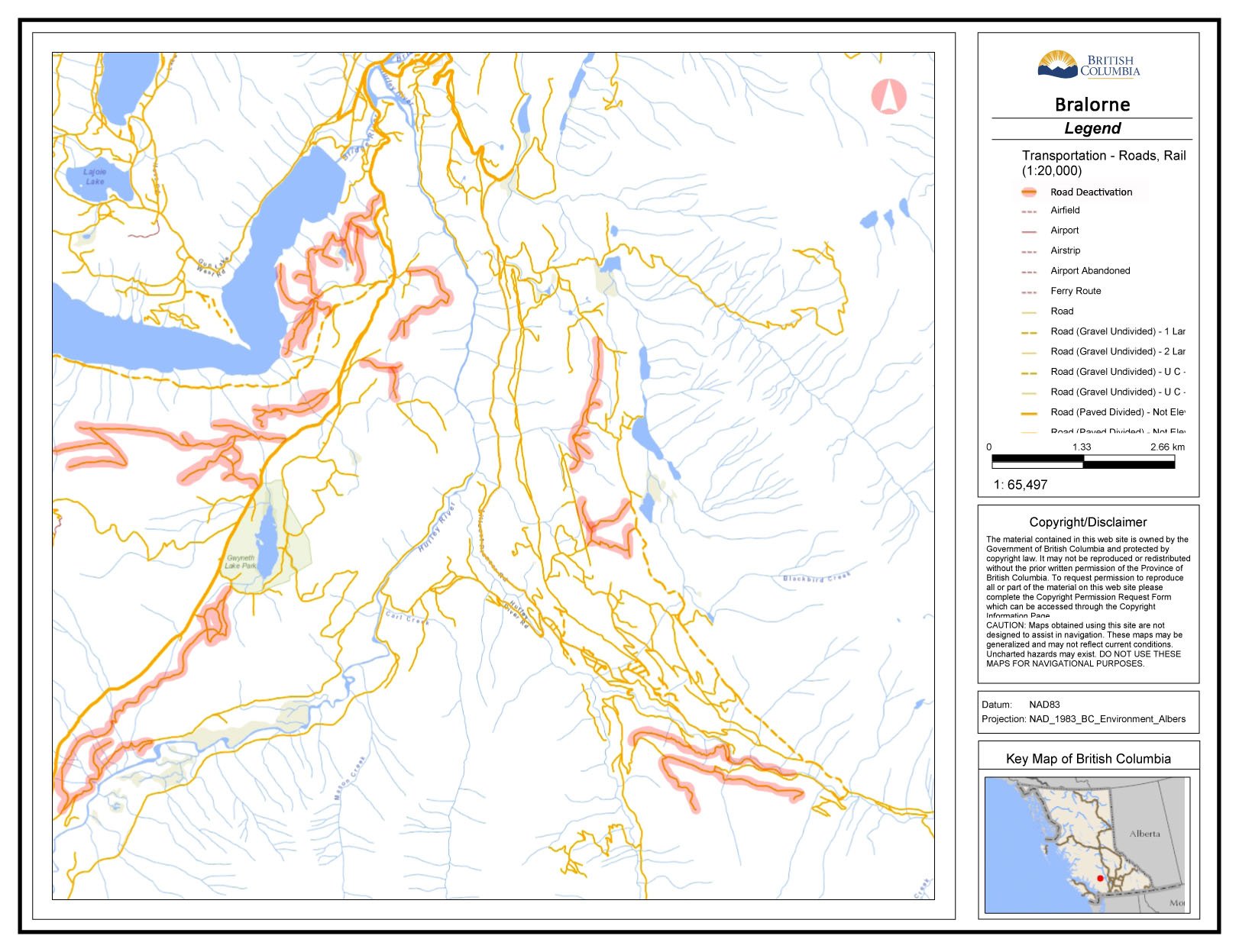 |
Maintain road density for industrial and recreational purposes | Minimal critical wildlife habitat |
| Bralorne in MU 3-33 |
Maintain road density for industrial and recreational purposes | Minimal critical wildlife habitat |
Pearson Creek in MU 3-32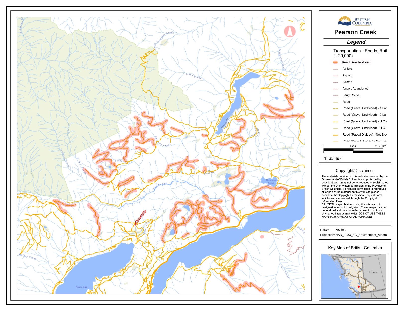 |
Deactivate all dormant logging roads; create road density reduction |
Purpose is to restrict all vehicles in: · prime mule deer winter range and spring fawning range · Grizzly bear spring habitat · Moose winter range |
| Plateau Ponds in MU 3-33 | Deactivate all dormant logging roads; create road density reduction |
Purpose is to restrict all vehicles in: · prime mule deer winter range and spring fawning range · Grizzly bear spring habitat · Moose winter range |
| Mud Lakes in MU 3-32 | Natural or man-made blockades at access points to roads east and north of Mud Lakes |
Purpose is to eliminate: · loop access in Yalakom Valley · road access to north to region 5
|
| Blue Creek in MU 3-32 | Natural or man-made blockades at access points to Black Dome Mine | Purpose is to eliminate unregulated access to region 5 |
| Hurley Pass in MU 3-33 | Maintain Ministry of Forests access management |
Purpose is to: · Minimize access from Region 2 until high level management plan is in place · Maintain use for snowmobile access in winter; aids tourism industry |
| Relay Creek | Natural shale slide blockade at Mud, Tyax, and Relay creek junction access point | Purpose is to reduce activity in spring and fall for mule deer, moose, and grizzly bear migrations |
Table 2. Priority Trail Management Measures
| Location | Trail Management Measure | Comments |
|
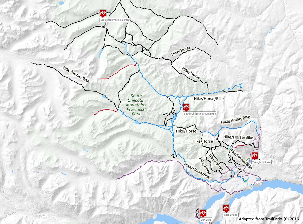
Gun Creek
|
Mainly for horses and hikers; limit mountain bike use | |
| B + F Creek | Limit to horses and hikers only | |
| Lick Creek | Limit to horses and hikers only | |
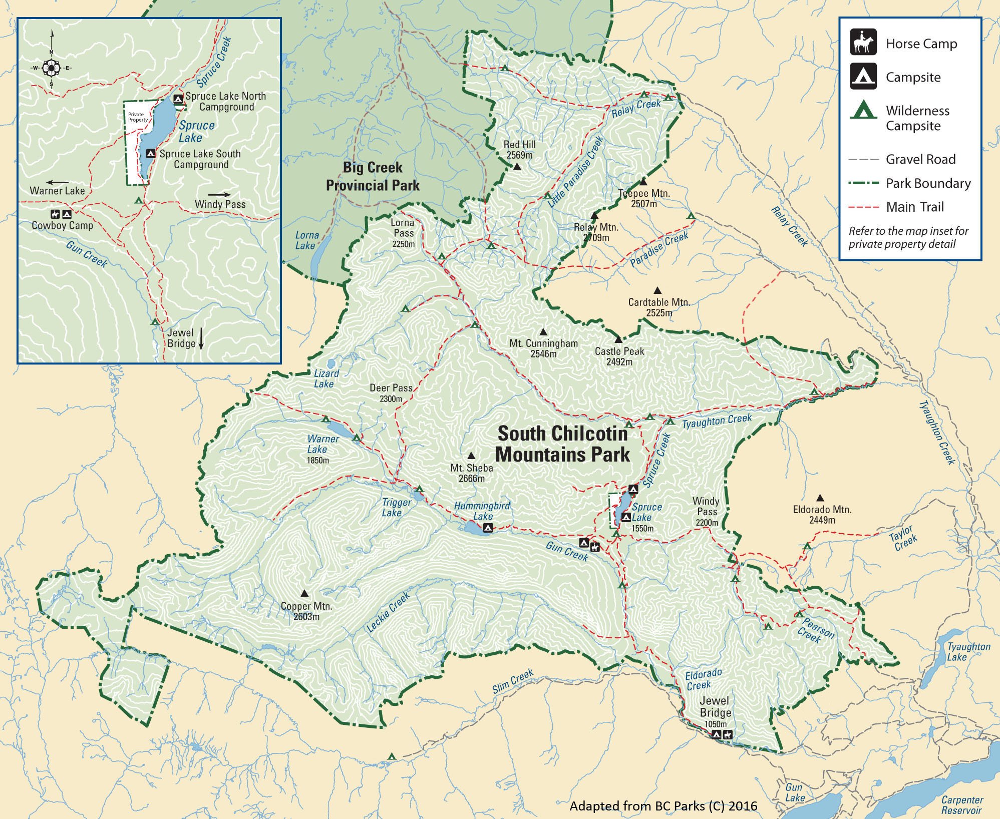
| Pearson Creek Mine Road | Designate trail end at park boundary | Trail in park boundary is above 1500 meters |
| Pearson Creek Area |
Close multi-use trail
|
Infringing on livestock, tenures, etc Must meet 0.06 km/km2 road density limit
|
| 5 Mile Ridge |
Close multi-use trail |
Infringing on livestock, tenures, etc Must meet 0.06 km/km2 road density limit |
| Marshall Ridge |
Close multi-use trail |
Infringing on livestock, tenures, etc Must meet 0.06 km/km2 road density limit |
| Carol, Marshall, Lisa Lakes | Close multi-use trail |
Infringing on livestock, tenures, etc Must meet 0.06 km/km2 road density limit
|
| Hope, Noel, Lone Goat, Slim Creeks |
Snowmobile access from January to March No motorized use the rest of the year |
No trail development off logging roads |
| Taylor Creek | Permit trail use by motorized vehicles only to to alpine mine cabin | High elevation use displaces wildlife |
| Shulaps* | Restrict all motorized access to below 1500m elevation only | High elevation use displaces wildlife |
| McGillivray Pass, White Cap, Connel, Ferguson and Steep Creek (Mt. Truax) |
Restrict all motorized access to below 1500m elevation only. McGillivray Pass is a designated trail suitable for horses and hikers; no motorized use. |
High elevation use displaces wildlife Prime Grizzly Bear habitat Sensitive wetland areas
|
| Cayoosh Range | Restrict all motorized access to below 1500m elevation only | High elevation use displaces wildlife |
| (9 Mile Ridge) | Restrict all motorized access to below 1500m elevation only | High elevation use displaces wildlife |
| Gun Lake | Permit motorized access along old logging roads west of Gun Lake | Maintain multi-use trails and open all road access |
| Gold Bridge |
Permit motorized access down the south side of Carpenter and along Cadwallader Creek | Maintain multi-use trails and open all road access |
| Bralorne |
Permit motorized access along the East Hurley and Cadwallader Road | Maintain multi-use trails and open all road access |
| China Head Mountain, Nine Mile Ridge, Red and French Mountain and Hogback Mountain | Prohibit motorized access above 1920 meters elevation | Motor vehicle closure under the Wildlife Act |
| Tyax Creek | Deactivate road | |
| Paradise | Deactivate road | |
| Relay | Deactivate road | |
| Bonanza Creek | Deactivate road |
*Shulaps include Quartz Mountain, Horse Lake, Blue Creek, Burkholder, Larachelle, Big Sheep, Liza, Jim Creek, Brett Creek and Hog Creek
Table 3: Access Management Terms and Management Intent
| Term | Description and Management Intent |
| Control point: A feature that controls access on a road; includes constructed features such as gates, ditches or berms as well as natural blockages |
· Use natural barriers (e.g., snow pack) as much as possible to meet environmental objectives but supplement them where necessary · Shown on each access map |
| Areas managed by regulation: Areas established under legislation (e.g., Wildlife Act, Forest and Range Practices Act) to manage motor vehicles |
· The plan proposes no change to permit requirements for industrial or commercial users · Areas include: year-round Wildlife Act restrictions at Red Mountain, China Head, French Bar, Nine Mile Ridge; June to November Wildlife Act restrictions at Spruce Lake; and year-round Forest and Range Practices Act restrictions on recreational use at Bonanza Creek · These areas will be reviewed during plan implementation to ensure they complement the plan’s approach to access management · Shown on each access map |
| Road density reduction areas: Areas with more roads than are needed to sustain resource development |
· Intent is to close or decommission roads that are inactive and costly to maintain or that pose a risk to public safety or the environment · Closing or decommissioning roads is the responsibility of permit holders, resource developers or government agencies, as appropriate · Shown on the All-Season Access map |
| Currently unroaded areas: Areas without roads |
· To maintain wildlife habitat and remoteness, new resource roads will be dedicated for industrial or commercial use only and closed when no longer needed · Shown on the All-Season Access map |
| Seasonal access management areas: Areas that have premium habitat for certain vulnerable species, such as mule deer in the winter or grizzly bears in the spring |
· Intent is to reduce motorized vehicle traffic for part of the year to meet defined environmental objectives · Limitations on access apply mainly to public and recreational users · These areas may be used for industrial or commercial purposes but users may need to limit or prevent non-business traffic and mitigate their own access-related impacts · Shown on the Spring Access, Summer Access, and Winter Access maps |
| Winter non-mechanized recreation: Areas that provide dedicated opportunities for back- country skiers, other non- motorized winter recreation use |
· Snowmobilers and other mechanized recreational users are encouraged to avoid them · Open to industrial and commercial use, including new resource roads, but impacts to recreational users should be considered · Shown on the Winter Access map |